Charts
Home >> Standard Operating Procedures >> Airport Procedures >> Charts
In most of our events, we use Kutaisi (Georgia) or Ramat David (Israel) as our main airport, depending on if we're flying in the Caucasus or Syria theatre. The following charts illustrate the layout of the airports. Typically, they are included as kneeboards in our missions, but are here so you can study them when not in the cockpit.
Innehåll
Kutaisi
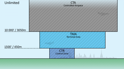
The airspace structure is usually viewed as an inverted cake, extending from the airport and up.
Ramat David
Resources
In Game Kneeboard
Drop the images contained in the file below in your C:\Users\YOURNAME\Saved Games\DCS.openbeta\Kneeboard folder to access section charts of Kutaisi CTA during flight.
Media:MA Kutaisi CTA kneeboard.zip
Tacview Objects
Drop the XML file into C:\Users\YOURNAME\AppData\Roaming\Tacview\Data\Static Objects to display Kutaisi CTA in Tacview.
LotAtc Overlay
Use the draw tool and open the json file to display Kutaisi CTA in LotAtc.
